Welcome To The Regenerative Waterscaping Series
Regenerative waterscaping is the art and science of shaping and tending landscapes to maximize the productive, ecological and aesthetic benefits of water as it moves through them. The 4 R’s Of Regenerative Hydrology details the paradigm that guides successful design and implementation of the many different types and variants of water patterning elements detailed in the remaining posts, and is a recommended introduction for the entire series. When applied in alignment with your holistic context (people, place and purpose), these elements will knit together to create the foundation for true abundance – a landscape that works with Nature.

Water Infiltration Elements
Introduction
Water infiltration earthworks are utilized to increase the effectiveness of the precipitation a landscape receives. Effective precipitation is that water which manages to percolate into the soil where it can be utilized by soil biota and plant life to capture more sunlight and grow more biomass. Ineffective precipitation is that which either runs off without being absorbed into the soil or is lost to evaporation. The water infiltration elements detailed here function to reduce run-off and evaporation losses while enhancing the soil’s infiltration and storage capacity when properly employed.
The various water infiltration earthwork elements detailed in this post are common prescriptions for maximizing water infiltration encountered in most, if not all, landscapes. Each element write up begins with a description of the element and the functions it performs, followed by a list of context-specific design criteria for determining whether or not it is appropriate in a given situation, general rules of thumb to follow when designing and installing it, and additional resources for continued learning.
Water Infiltration Earthworks Index
*click to jump to a specific element

Swales
Description: Swales are shallow ditches dug following a contour line (a level line that is always perpendicular to the slope it is crossing), with the soil excavated from the ditch mounded into a berm on the downhill side of the ditch. The bottom of the ditch and top of the berm are both level all the way across the landscape – which will create a long, thin, temporary “lake” when filled with water. The berm and the bottom of the ditch are left uncompacted to maximize the swale’s infiltration capacity. Swales are typically 1-3 feet deep and 1-12 feet or more across, though can be much broader and shallower in deserts and areas with fragile soils prone to wind erosion.
Function(s): Swales capture sheet-flow and point-source run-off water in a level-bottom ditch, slowing it down and spreading it out across the landscape on contour. This allows water that may have otherwise run off the landscape a chance to infiltrate into the soil, creating a saturated “lens” of subsoil downslope, where it can be put to beneficial use growing trees and other perennial vegetation, recharging aquifers, charging downhill springlines and increasing soil moisture levels. Swales are ultimately tree establishment elements, with trees either being planted on or just below the berm along its entire length. Swales will turn into forested terraces over time if sediment is not removed from the ditch. The swale berms are generally planted with productive perennial vegetation that will help to further enhance the infiltration capacity of the swale, in addition to providing a host of additional ecosystem services.

Uppermost swale in the newly formed Casitas Valley Farm swale system during its first rain event. 
Newly formed swale during first rain event. Casitas Valley Farm 2014. 
Newly formed swale during first rain event. Casitas Valley Farm 2014. 
Freshly installed swales immediately after the earthworks course. 
Digging the top swale in the system. Casitas Valley Farm 2014. 
Freshly dug swale. Casitas Valley Farm 2014. 
Two swale lines connected by a rolling dip across a section of gravel driveway. 
Newly dug swale line following contour through an existing olive orchard. 
Newly dug swale line following contour through an existing olive orchard. 
Newly dug swale line connecting an intake off a paved road and using that water to hydrate the orchard below. 
Level-sill spillway at the end of a swale discharging into a rolling dip. 
Swale line crossing an existing vineyard. 
Rolling dip transiting across compacted roadbase driveway into a swale. 
Digging a small swale to collect roof run-off above the location for a soon-to-be market garden. 
Flatland swale system panorama – linked central drain diverts laterally into infiltration basins. 
Sandbag diversion from central drain into swale basin 
Sandbag diversion from central drain into swale basin. 
Detention basin full following first rain event. 
Detention basin full after first rain. 
Porous sandbag diversion doing its job – diverting water to fill the detention basins while permitting overflow down the main channel. Note the source of the inbound run-off, the neighboring broccoli field, in the background. 
Swale capturing driveway run-off set above terraced hillside orchard. 
Bottom swale catching run-off before it exits the property. 
Swale installed above several earth terraces for a future food forest planting.
Context-Specific Design Criteria for Swales
Swales are generally a good fit for a specific context when:
- The land under consideration currently has few or no trees.
- The soil has relatively low permeability/infiltration rates (often found where soils have a significant clay content), with significant depth to bedrock.
- The slope is less than 20% grade (steeper slopes sometimes permit swales, but there are more factors to consider).
- There is adequate catchment area uphill of the proposed swale location that can be directed into or captured directly by the swale to make it a worthwhile installation.
- Grazing animals can be excluded from the swale ditch and berm.
- The site receives rain on frozen ground/snow, or sees temperature swings that result in rapidly melting ice/snow.
Swales may not be a good fit for a specific context when:
- The location is already forested, with a healthy humus/mulch layer- we can’t do better than this!
- The slope is greater than 20% grade.
- Steeper grades mean more soil has to be moved for less water-holding volume.
- There is a greater erosion risk upon discharge over a level-sill spillway.
- NOTE: Swales can still be valuable elements on steeper sites – it’s just that greater care must to be taken in their construction and in patterning discharge in a non-erosive way (generally more rock is required to armor spillways and follow up structures to dissipate concentrated energy in flowing water – see Media Lunas, One-Rock Dams, Armored Rundowns)
- Site is composed of shallow-ish clay soils sitting atop impervious bedrock.
- Clay can become fully saturated and slip off the bedrock, leading to swale blowouts and bad erosion damage.
- In particular check for dispersive clay, which is more prone to liquefaction.
- There isn’t enough overland sheetflow to make a swale (or at least the swale size being considered) worthwhile (i.e. it wouldn’t fill up even in a 100-year flood scenario).
- The soil has relatively high permeability/infiltration rates (often found where soils are sandy). If nothing is running off, there is no need for a swale.
- Grazing animals have uncontrolled access to the swale berm.
- A single cattle or pig trail can downcut through a swale berm, destroying its design function and initiating erosive processes.
General Design & Installation Considerations for Swales
- Swales should be sized based on the amount of rainfall they need to hold and infiltrate.
- Generally, swales in drylands will be larger to accommodate infrequent yet heavy rainfall events to ensure as much water as possible is captured and infiltrated.
- Swales in more humid climates are generally smaller due to higher rainfall frequency.
- Swales should be sized according to the kind of access required.
- Swale bottoms can be built to accommodate large or moderately-sized agricultural machinery, or handcarts, or foot access only.
- Where livestock will be used, swale bottoms can be part of their grazing paddocks and be used as access laneways between paddocks.
- Swales will silt in over time, and this is OK provided their function is replaced and enhanced by trees or other perennial vegetation.
- Swales are always level at the bottom of the ditch and top of the berm.
- Swales can be constructed using a variety of implements. Small swales can be created using shovels, hoes, picks and tampers, while larger swales are generally cut with an appropriately-sized excavator or a bulldozer driven across-slope on shallow grades.
- A swale will have a measurable holding capacity as well as a generally known infiltration rate. There may be rain events during a swale’s functional lifespan that exceed its capacity to infiltrate standing water as fast as new water is entering. When these events occur the swale will overflow, and thus planned overflow points called level-sill spillways – which allow for water to be discharged from the swale ditch safely without eroding the berm or downslope soils – are an essential component in the design of swale systems.
Resources for Continued Learning about Swales
- YouTube Playlist: Passive Water Harvesting Earthworks – Swales
- Rainwater Harvesting For Drylands & Beyond – Brad Lancaster
- Permaculture – A Designer’s Manual – Bill Mollison pgs. 155, 167-169, 337-345.
- The Permaculture Handbook – Peter Bane pgs. 77, 161, 202-203.
- Water for Any Farm – Mark Shepard

Infiltration Basins
Description: An infiltration basin is a depression into which direct precipitation, sheet-flow, and point-source run-off water is directed and temporarily stored to give the water a chance to infiltrate into the soil. Infiltration basins increase local soil moisture, which helps to grow trees and other perennial vegetation, recharge aquifers, charge downhill springlines. Infiltration basins can range in size from small depressions an arm’s length wide to multi-acre basins designed to collect run-off from large hardscapes or high runoff areas. Infiltration basins are specifically engineered to have high infiltration rates – the whole idea is to get water into the ground as efficiently as possible – i.e. “earth storage”. By detaining large surge flows, infiltration basins also help to reduce erosion.
Infiltration basins are also called pocket ponds, detention basins and rain gardens depending on the context in which they are installed, however they all function to capture and infiltrate surge flows, much like swales (infiltration basins can be integrated with attached swale lines to enhance water harvesting capacity and infiltration potential). These ephemeral basins will provide valuable seasonal habitat to many forms of wildlife, in addition to allowing for the growth and persistence of different vegetation communities. The persistence of water in these locations for longer into the dry season allows for enhance crop and biomass production on the edges of the basins.

Existing ag field run-off running straight through the middle of the property. 
Existing run-on situation from up-watershed ag fields. Note the coffee colored water – laden with silt and bed load from the tilled fields. 
The basic plan to create a network of detention basins off of the main channel, linked with an infiltration basin and level-sill outlet. Also remodeling an existing pond in and installing a rolling dip and 1% drain to capture another 19 acres of catchment run-off. Flatland swale system panorama – linked central drain diverts laterally into infiltration basins. 
Sandbag diversion from main channel into detention basins. Sandbag diversion from central drain into swale basin Sandbag diversion from central drain into swale basin. 
Infiltration basin at entry point of run-off from neighboring broccoli field. Armored sill in the foreground is marks the property line. Porous sandbag diversion doing its job – diverting water to fill the detention basins while permitting overflow down the main channel. Note the source of the inbound run-off, the neighboring broccoli field, in the background. Detention basin full after first rain. Detention basin full following first rain event. 
Bulldozer cutting another detention basin. 
Remodeling the old pond – going deeper and building the wall a bit higher to increase its holding capacity. 
Pond remodel. 
Finished remodeled pond prior to mulching the dam wall.
Context-Specific Design Criteria for Infiltration Basins
Infiltration Basins are generally a good fit for a specific context when:
- Large volumes of surface run-off or point-source run-off would otherwise have no chance to infiltrate before running off the property.
- Hardscape elements that require 4-season functionality (sidewalks, paved roads etc.) generate more run-off than can be shed and infiltrated by the surrounding terrain in its current form.
- In this case, elevated roadways with sunken basins adjacent allow for excess surface flows to drain and infiltrate without impairing road function.
- This is seen frequently at major airports – lots of hardscape, with sunken basins in between runways to provide a place for the surge flow to go and keep runways usable.
- Soils are porous enough to actually infiltrate – if not, a pond will be created.
Infiltration Basins may not be a good fit for a specific context when:
- Soils are too heavy or clay-rich to infiltrate effectively.
- NOTE: Infiltration basins can still be valuable in these circumstances, but may need to be more numerous or larger to compensate for their much slower infiltration rate. The bottoms of the basins should also be ripped (with machinery) or fractured (with hand tools) to increase porosity. Basins should be planted densely with tap-rooted trees and vegetation to increase the infiltration capacity in such an environment.
General Design & Installation Considerations for Infiltration Basins
- Infiltration basins are typically shallow and broad, but this does not have to be the case.
- Edges of infiltration basins should be vegetated whenever possible to enhance infiltration potential and increase the productivity of the system overall. Basin bottoms can also be planted with vegetation that tolerates seasonal inundation, which will further increase infiltration and reduce evaporative losses.
- Infiltration basins function best when integrated with other passive water harvesting elements, such as:
- Swales – for enhancing water harvesting and infiltration potential,
- Water storage tanks – as areas where tank overflows can be safely directed to benefit that larger landscape.
- Access roads and pathways – to enhance effective drainage of the access route and maintain their structural integrity during wet conditions.
Resources for Continued Learning about Infiltration Basins
- YouTube Playlist: Passive Water Harvesting – Infiltration Basins
- Brad Lancaster’s website: HarvestingRainwater.com
- Book: Rainwater Harvesting – for Drylands and Beyond – Volume 1 – Guiding Principles To Welcome Rain Into Your Life And Landscape, Brad Lancaster.
- Book: Water for Any Farm – Mark Shepard

Boomerang Berms
Description: Boomerangs are berms built in the shape of a boomerang, with the convex part pointing downslope, to create small soil and water retention basins to aid plant and tree establishment and production. They efficiently harvest water from the larger surface area uphill of the planting area due to their open shape. Boomerangs are well-suited to steep and shallow grades, as they capture inbound sheet flows and offer the water an opportunity to infiltrate while reducing the potential for channelization, rill formation and subsequent erosion. The tips of each boomerang overlap the two boomerangs below it, much like fish scales (sometimes boomerangs are referred to as “fish scale swales”), and so create a “net” of interlocking micro-water harvesting basins.
Function(s): Boomerangs are effective at capturing and infiltrating direct precipitation, sheet-flow run-off, and point-source run-off water to grow trees and other perennial vegetation. Enhanced infiltration high in the landscape will help to recharge aquifers, charge downhill spring lines and increase soil moisture levels. They are also effective at preventing or reducing down-watershed erosion

Context-Specific Design Criteria for Boomerang Berms
Boomerang Berms are generally a good fit for a specific context when:
- Soil infiltration rates are relatively high.
- Locally productive tree and plant species either tolerate or thrive during periods of seasonal inundation.
Boomerang Berms may not be a good fit for a specific context when:
- Landform is so steep that excessive amounts of material would have to be imported or dug in order to create an effective boomerang berm.
- Soils have poor infiltration rates due to high clay content or compaction.
- Target tree and plant species don’t appreciate or tolerate having their roots wet for prolonged periods.
General Design & Installation Considerations for Boomerang Berms
- Boomerangs are generally utilized for tree establishment on slopes in drylands. They can be a great way to make use of rock if large amount are present on site.
- They are effective erosion control measures at the rill stage of downcutting and channelization in uplands, typically found prior to entering the steeper, higher energy transport zones.
- Boomerangs can be built using sing stones found on site, repurposed urbanite, or simply hand-dug earth to create infiltration basins right around the tree’s root zone, as well as guiding any overflow of the basin into the next basin downhill.
- The uphill tips of each boomerang should be set at the same contour, so that any overflow from the basin will discharge evenly from both sides of the boomerang.
- For installations amongst existing trees, any digging should occur outside of the tree’s current dripline so as to avoid disturbing or burying the bulk of existing feeder roots or the boomerangs can be built up with stones, manure, mulch or soil from elsewhere.
- For installations in future orchard areas, it is recommended that the berms be dug and installed prior to planting.
Resources for Continued Learning about Boomerang Berms
- YouTube Playlist: Passive Water Harvesting – Boomerang Berms
- Brad Lancaster’s website: HarvestingRainwater.com
- Book: Permaculture – A Designer’s Manual – Bill Mollison pgs. 395-397

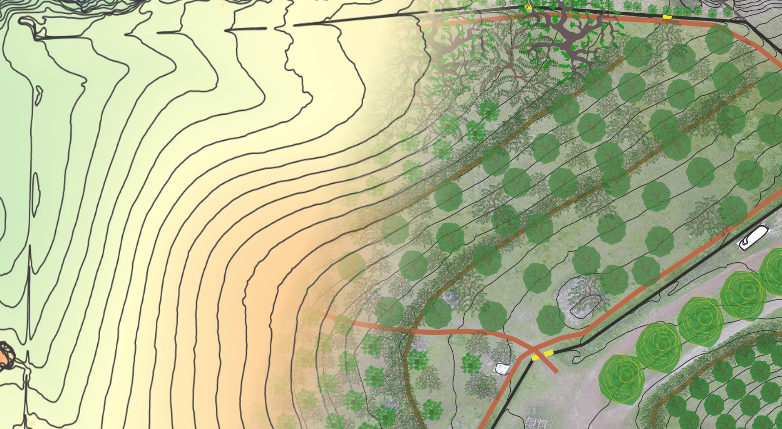
Terraces
Description: A terrace is a flat area created on a slope. Terraces are often created in a series, with one terrace above or below the next, following contour, much like a set of stairs. Terraces can also be constructed to create new contour patterns that were not present in the landscape. Terraces can be quite broad and wide in areas with shallow slopes, or very narrow in areas with steeper slopes. Terrace edges can be stabilized biologically, geologically, or with some combination of both methods.
- Biological stabilization employs deep rooted perennial grasses (like vetiver grass), shrubs or trees planted in close proximity to help anchor and protect terrace edges. Biological stabilizing systems can also become part of the cropping system, providing cut forage, shade, mulch, while enhancing infiltration and sediment collection.
- Geological stabilization employs stone, masonry or shaped-earth to hold the terraced soil in place, and allows for steeper banks between each terrace, thus increasing the amount of usable flat area.
Function(s): Terraces have been employed by human civilizations for ages as an effective method for retaining soil and moisture, building fertility and creating productive food systems. In addition to slowing and spreading precipitation and thus allowing it time to sink into the soil rather than run off, terraces create level access across slopes, help build and retain soil (by catching what runs onto them and keeping what is generated on-site), and create usable space for the production of crops and livestock. Terraces are also very effective on hillsides with shallow topsoil as a means to evenly distribute the available topsoil to plantings.

Lonely Palm Ranch old orchard before terracing. 
Lonely Palm Ranch new orchard zone after terracing. Top cut in the picture is a swale picking up driveway and roof run-off from the workshop. 
Lonely Palm Ranch terraces with irrigation mainlines laid. 
Lonely Palm Ranch orchard terraces. 
Lonely Palm Ranch orchard terraces cover-cropped and straw mulched – ready for rain! 
Broadacre terraces with grassed waterway down the center. 
Swale above three terraces. 
Planned terraces, swale, spillway and media luna flow spreaders. 
Three terraces below a swale infiltrating driveway run-off. 
Terraced food forest planting area completed. 
Terraced food forest planting area complete. 
PFH terracing completed – swale, terraces, spillway, media lunas.
Context-Specific Design Criteria for Terraces
Terraces are generally a good fit for a specific context when:
- Slopes are such that they can be made adequately wide without too large or too steep a batter (slope between terraces).
- Cross-slope access will benefit the larger system.
- In sloped areas where workable ground is scarce – terracing can greate level ground that can be worked safely and efficiently.
Terraces may not be a good fit for a specific context when:
- Located in clay soils sitting atop shallow bedrock – excessive water retention can lead to slippage.
- A significant point-source of water must be infiltrated – best to do this with a swale or infiltration basin that has a larger surge volume located above terraced cropping areas.
General Design & Installation Considerations for Terraces
- The use of terraces require suitable site conditions and proper design and implementation in order to function correctly and have longevity. If due diligence is not performed in the design phase, there are some large risks.
- Any retaining wall acts as a dam for the soil and water behind it. Like a dam, a retaining wall will fail if the pressure behind it grows too great. Heavy rains can cause a retaining wall to fail; so too can construction on a neighboring property that changes the flow of water downhill. The collapse of a fill terrace can cause significant damage, but cut terraces involve an additional dimension of risk. For example, if the native soil has a heavy clay content, and sits directly on top of bedrock, during heavy or long-duration precipitation events excess water retained on the terrace can hydrate the clay to a point where it becomes unstable (as is the case with expansive clays). This can cause slippage and failure. Therefore, depending on one’s climate, the native soil composition, degree of slope and desired function of the terraces, it may be desirable to design the terraces so that they do not retain water, but instead evenly shed it across the downhill cut edge or to a drainage channel on one (or both) sides.
- Avoid constructing large terraces or terraces that retain water if soils are composed of expansive clay sitting atop bedrock, especially in high-rainfall regions.
- Research the historical rainfall intensity in the area (more important than the amount of rain received in a year is the intensity and amount of rain received in a 12-, 24-, and 48-hour period of time). Plan for the safe discharge of water during high intensity rainfall periods.
- In drier climates it can be appropriate to angle terraces into the slope.
- As a general rule of thumb, the total area of the terraces in arid areas should not exceed 1/20th (5%) of the total catchment area that feeds them. For tropical areas no more than 30% of the catchment should be put into terraces.
- In areas with heavier rainfall and/or an abundance of snow the bank should fall to the outside of the slope so that water coming down will not drain into the slope.
- Avoid situating the terrace where it will intercept too much runoff, perhaps from the roofs of houses and garages, or from drainage pipes farther up the hill – better to channel concentrated flows like this into a structure like a swale or infiltration basin above or below the terraced area (via a pipe or armored drain on one or both sides of the terraced area).
- Continually improve soil on the terraces with the incorporation of organic material to improve water penetration. Mulch the soil surface to reduce the potential for surface runoff. Secure terrace walls with biological retaining walls – deep rooted perennial grasses and non-competitive trees are good choices. Biological retention systems grow stronger with time, unlike many geological retention methods.
Resources for Continued Learning about Terraces
- YouTube Playlist: Passive Water Harvesting Earthworks – Terraces
- [PDF] – NRCS Conservation Practice 600 – Terraces
- Brad Lancaster’s Rainwater Harvesting For Drylands & Beyond – Passive Water Harvesting
- Book: Bioengineering For Land Reclamation And Conservation – Hugo Schiechtl pg. 3
- Book: Lo-TEK – Design By Radical Indigenism – Julia Watson pgs. 30-45, 74-107
- [PDF] – A Field Guide On Bench And Terrace Construction
- [PDF] – USDA NRCS Field Engineering Handbook – Part 650 – Chapter 8 – Broadacre Terraces (scaled to accommodate large agricultural machinery).
- Book: Permaculture – A Designer’s Manual – Bill Mollison pgs. 236-237
- Book:The Permaculture Handbook – Peter Bane pg. 204

Keyline Subsoil Riplines
Description: Keylining – a.k.a. keyline subsoil ripping / plowing – uses the Yeoman’s Keyline plow to fracture compacted soil without inverting it – creating subsurface channels capable of rapidly improving infiltration across broad acre landscapes. Keyline plowing is done following or just slightly off contour, depending on whether the goal is to infiltrate water right where it is intercepted by the channels made by the plow tines or move it passively from points of high concentration to low concentration.
Keyline plowing is but one methodology employed within the larger Keyline Design system. Keyline Design is a landscape design technique employed to rapidly increase the depth of living soil and increase moisture retention and persistence throughout broadacre landscapes. Keyline Design emanates from a point in the landscape called the keypoint, a specific location in the descent of a valley where the slope transitions from convex to concave (i.e. goes from steepening to flattening). This point is identifiable on a topographical map as the location where the contour lines in the valley center transition from being close together (steep) to further apart (less steep). The contour line passing through the keypoint is called the keyline, and it extends from the keypoint towards the ridges, terminating where the valley walls are at their steepest. The keypoint and keyline are illustrated in the images below.


Function(s):
- Keyline plowing as part of a larger keyline design is used to spread water from areas of high concentration (valleys) to areas of low concentration (ridges) and improve soil moisture infiltration and distribution.
- Keylining aids the rejuvenation / reseeding of pastures when ripping is simultaneously conducted with application of biological stimulants (compost teas, effective microbes etc) and seed directly into the rip lines.
- Keyline riplines are also an excellent method to prepare ground for tree planting, as they help to flocculate the soil above the ripline by creating a pressure wave, much like the bow wave of a large ocean tanker that dolphins like to surf, enhancing its ability to infiltrate water and deliver oxygen to developing tree roots.

Context-Specific Design Criteria for Keyline Plowing
Keyline Subsoil Ripping is generally a good fit for a specific context when:
- Valleys are broad and wide and with mild slope transitions, and ridges are long and low.
- Slope angles, when measured perpendicular to contour can be safely traversed by the tractor without risk of rollover.
- Soils are free of large rocks and tree roots that would impede the plow.
- Treatment can be applied to an adequately large and contiguous area to make it worth while.
- Hardpan is present.
- The landscape is managed using holistic planned grazing to maintain and increase soil health following the keyline plow treatment.
Keyline Subsoil Ripping may not be a good fit for a specific context when:
- Slope gradient following the keyline towards the ridge is too steep for tractor to drive across the slope (this will depend on the tractor being used – reference the owner’s manual and look up safe slope traverse angles).
- As a general rule of thumb, most tractors should not drive across slopes that are steeper than 33% grade, the same as a 3:1 (x:y) slope which equates to a slope angle of 18.4°.
- Soils are rocky – this will damage the plow tines or make sinking the tines to the appropriate depth impossible altogether.
General Design & Installation Considerations for Keyline Plowing
- Keyline plowing should always be undertaken as part of a larger holistic design to optimize water distribution throughout a landscape.
- Paths for subsoil ripping should be surveyed and marked prior to plowing to ensure a consistent grade is maintained in keeping with the larger design vision and targeted functional outcomes.
- When establishing or re-seeding pasture in conjunction with keyline plowing, it is recommended to set the depth of the tines no deeper than the depth the seed being planted will be able to send down roots to during the first year of growth.
- Keyline plowing is meant to be down to “jump start” a healthy soil / water / mineral cycle over the course of one to several years – it is not a “forever” practice that should be done every year.

Resources for Continued Learning about Keyline Design
- YouTube Playlist: Passive Water Harvesting – Keyline Design System
- Home Website: Keyline Design
- Temperate Climate Permaculture: Introduction To Keyline Design
- [PDF] – The Keyline Plan – P.A. Yeomans
- Book: Water for Any Farm, Mark Shepard
- Book: Water For Every Farm – Yeomans Keyline Plan, P.A. Yeomans
- [PDF] – Soil, Water & Carbon For Every Farm – Abe Collins & Darren J. Doherty
- YeomansPlow.com – Creating The Yeoman’s Plow
- [PDF] – The Challenge of Landscape – P.A. Yeomans
Explore the rest of the Regenerative Waterscaping Series


2 responses to “Water Infiltration Elements”
[…] harvesting water from road surfaces. The dip-drain portion of the rolling dip can be let out into swales, ponds, infiltration basins, or lead out ditches patterned into keyline ripped soil where the water […]
[…] Ponds can be designed to maximize infiltration into groundwater (aquifer) or soil storage, in which case they are typically referred to as infiltration basins. […]