
Foundational Site Assessment
Location: Templeton, CA
Land & Climate Characteristics: The 10 acres are all set on a generally south-facing secondary ridge, with dominant solar aspects ranging from southeast to southwest. Much of the property has steep grades, ranging as high as 36% in some places. Soils were thin and eroded to shale bedrock in some places, with very low organic matter, high erosion susceptibility, low water-holding capacity and very low soil biology. The prior owners had set-stocked livestock, and the pasture areas showed evidence of both over-grazing and over-rest, with many manure clumps greater than 2 years old still sitting on the ground untouched. Pastures are dominated by annual grasses and forbs.

Client’s Foundational Site Assessment Objectives: The clients envision creating an abundant homestead with ample food production (annual and perennial) to share with family, friends and community.
Foundational Site Assessment Key Takeaways
- Water
- During a typical Templeton rain year of 17.5 inches, this property receives ~4.75 million gallons of direct precipitation within property bounds, of which ~ .71 – 2.14 million gallons is lost as run-off (15-45%). An additional .4 – 1.2 million gallons flows onto the property from off-property catchment areas.
- Water harvesting earthworks were recommended, and ultimately designed and installed to support the new food forest that was soon to be planted.
- Access
- Minor access alterations were recommended – primarily the addition of specific surface cross drains to improve drainage from low-standard road surfaces to enhance their longevity and decrease the maintenance load.
- Living Systems
- The property has a history of overgrazing, with infertile soils (almost pure sand on the ridges, some fine sandy loam in the valleys) and low soil-biology, as evidenced by the years-old livestock dung still persisting on the ground. The formerly grazed areas are largely dominated by annual broadleaf weeds and grasses.
- A perennial backbone of drought-resilient nitrogen-fixing trees will be of great help in re-establishing soil fertility, enhancing hydration and reducing run-off, all while generating food for livestock, which, provided they are managed holistically with high-rotation grazing, will be the most rapid means by which to bring the soils back to health.
- Energy
- Existing structures were evaluated for their solar PV and solar thermal integration potential.
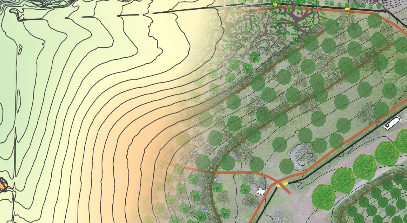
Terracing + Water Harvesting Earthworks
Implementation Scope: Passive water harvesting earthworks and erosion control system to create the physical skeleton for the planned food forest on the south facing ridge crest below the main residence.
- The earthworks served to improve access by foot and vehicle to the food forest zone via the creation of an access ramp leading to an upper terrace.
- An upper swale was installed to harvest run-off water that had been exiting the property down the paved driveway, instead patterning it on contour to allow it time to infiltrate.
- Three additional terraces were installed below this swale to act as the primary growing area. A series of media luna flow concentrators/spreaders were installed to pacify discharge over the level sill spillway in the event of a heavy precipitation event.
- Just below the valley keypoint (where the slope transitions from convex to concave) in the valley below, a second swale was installed to capture any discharge and allow it to infiltrate uphill of the deep valley soils which will be prime growing area in the future.
- This system will harvest and infiltrate between .5 – 1.25 million gallons of water per average rain year that would otherwise be lost to run-off, and improve moisture persistence in the soil to nourish the food forest and wildlife habitat plantings to come.

Before & Afters


Implementation Gallery

Excavator starting on the top swale. 
Leveling the top swale ditch bottomas we go. 
Skidsteer starting on the tractor access ramp to the upper terrace. 
Excavator finishing the tractor ramp to the upper terrace. 
Finaly terracing shaping and filling in the trench for the re-routed water main. 
Earthworks complete, straw bales ready to spread mulch after cover crop seed is spread. 
Lower media lunas approaching the bottom swale. 
Bottom “last chance” swale that will capture, hold and infiltrate any discharge from the upper swale during an intense precipitation event.
Implementation Video Walkthrough