
Mainframe Water & Access Design
Location: San Luis Obispo, CA
Land & Climate Characteristics: The property is composed of three distinct ridges descending to the southwest, with hillsides containing predominantly sandy-clay loam soils with high susceptibility to erosion, moderate to high permeability, high run-off potential, and low water storage profile (20-40” to paralithic bedrock). These hillsides are largely dominated by annual grasses and forbs and upland vegetation encroaching right to the edge of the riparian corridors. Due in part to past clear-cutting and grazing practices and long periods of over-rest, a large amount of dead and oxidizing plant material is left standing each year, which ultimately inhibits the growth of young plants (especially desirable perennial native grasses) and decreases the soil’s water infiltration and holding capacity.

Three distinct drainages descending to the southwest that have limited riparian vegetation and are deeply incised and actively eroding, with 64 headcuts counted at the time of the site visit. This erosion is creating an increasingly dehydrated landscape year over year.
Average rainfall of 22 inches per year, with approximately 90 million gallons (272 acre-feet) of precipitation falling within property bounds per average rain year and another 26 million gallons (80.4 acre-feet) falling on approximately 44 acres of adjacent property to the east that ultimately drains into the SLO Botanical Garden property.
An estimated 8 – 27 million gallons (25 – 83 acre-feet) of the average annual precipitation that falls within property bounds is lost to runoff, and an additional 1 – 6 million gallons (4 -20 acre-feet) of the average annual precipitation that lands on the adjacent contributing watershed to the east runs onto and ultimately exits the SLOBG property. The average runoff levels are likely increasing year-after-year, which is exacerbating dehydration of the hillsides and erosion in the drainages.
The roofs and hardscapes of the Visitor Center and Education Center Hubs as illustrated in the SLO Botanical Garden’s 2022 Master Plan make up approximately 4 million gallons (12 acre-feet) of the total estimated runoff
Clients Goals and Vision: The SLOBG team of directors have communicated their desire for this water system to rehydrate the soils of the property’s broader landscapes in order to provide passive hydration to current and future plantings for longer into the dry season, be able to actively irrigate new plantings with collected rainwater, and reduce erosion.
Video of Existing Severe Headcut Erosion
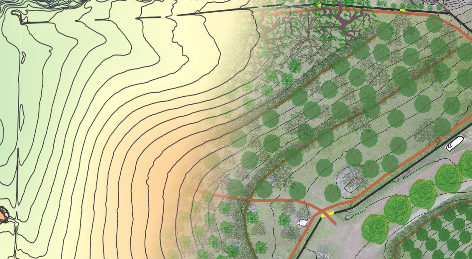
Mainframe Water & Access Design Elements
- Water
- A passive water harvesting system designed to slow surface runoff that develops during rain events, spread it out towards the ridges, and ultimately infiltrate it into the soil in order to provide hydration to downslope vegetation and minimize the amount of runoff entering the eroding drainages.
- The proposed network of linked passive water harvesting elements including infiltration basins, swales, and boomerangs located at strategic points throughout the landscape will infiltrate an estimated 7 – 21 million gallons (21-64 acre feet) of surface runoff that is currently being lost from the property.
- Water-harvesting micro-earthworks in the broad acre planting protocols to increase infiltration and maintain dispersed sheet-flow during precipitation events. Small earthworks installed by hand at the time of planting around each specimen tree or plant will serve to increase moisture availability and retain topsoil and mulch to help plants establish well and maintain themselves for a long, healthy life. Applied across the broadacre, these earthworks will increase soil moisture and organic matter and ultimately create a landscape that “pops” in a big way when bloom season arrives.
- Aggradation structures in the drainages to accumulate sediment and enhance moisture retention. These will 1) halt existing headcut progression in its tracks and save any additional soil from being lost, and 2) provide an opportunity to revegetate drainage bottoms with desirable species by accumulating sediment, banking moisture and intentionally re-introducing California native riparian species that have been lost.
- An active water harvesting system designed to maximize collection, storage and infiltration of the run-off that develops on the roofs and hardscapes of the Visitor Center and Education Center Hubs. This proposed network of cisterns and tanks with overflow basins and swales will allow for the storage of up to 4 million gallons (12 acre-feet) per average rain year in tanks and in the soil located high in the landscape, which can be used to irrigate downslope plantings via gravity.
- A passive water harvesting system designed to slow surface runoff that develops during rain events, spread it out towards the ridges, and ultimately infiltrate it into the soil in order to provide hydration to downslope vegetation and minimize the amount of runoff entering the eroding drainages.
- Access
- Adjustment to existing pedestrian and vehicle access patterning to avoid concentrating surface sheet flows and creating future erosion problems while simultaneously utilizing access routes as passive water harvesting and landscape hydration structures.
Design Maps


